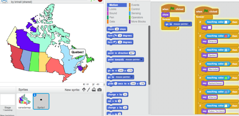
In this activity we are going to code an interactive map of Canada.
Thanks to Ryan Smith (@ryan_psmith) for the lesson plan.
This. Totally This. https://t.co/bDapD4WPxM
— Brian Aspinall (@mraspinall) October 16, 2016
The Scratch app will detect what colour your mouse cursor is hovering and reveal the appropriate Province or Territory. In order to correctly build this app, students would have to know accurately the location of each.
My project page can be found here: https://scratch.mit.edu/projects/125995170/#player
To view Ryan’s full lesson, click here:
https://docs.google.com/document/d/1SOHSvpOg2-RHkHK1KDH9PM6nnlUM6ZVhvwrSl5a0ypQ/
This is a great way to engage kids in Geography, logical reasoning and computational thinking. I would challenge them to extend the application by making it into a quiz.
For more lessons, activities and ideas, grab a copy of my book, Code Breaker, on Amazon here!
(Visited 5,247 times, 1 visits today)
 For all the kids who grow up in a small town and think they don’t stand a chance. You do. I was once that kid.
I am planning on making a life sized map of Canada to be interactive with makey makeys but this is a great intro activity. Thank you so much for sharing!!!